includes


Price: $149.00
(as of Mar 09, 2023 13:11:38 UTC – Details)

includes

Product Description

Push pin mapsPush pin maps

USA National Parks MapUSA National Parks Map

Explore America – Unique map features over 600 National Park Sites and historical sites across America.

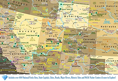
About The Map: Our US National Parks Map with Push Pins – Brown Edition is THE most detailed National Parks Map available anywhere! This unique travel map features all of the National Park Service Sites, Historical Cities, National Monuments, Battlefields, Lake Shores, Preserves, and other fascinating destination spots preserved for our nation.

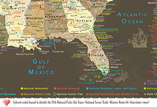
Professionally Made: Created by a professional geographer/cartographer, the research and design for this USA map took over a year. We worked with official National Park Service data to uniquely display and reference ALL of the 600+ sites in the USA. Every reference has been thoroughly researched, symbolized, and carefully labeled on the map. A unique referencing system has been developed for areas that have many National Park Service sites and a unique colored coded label system has been created on the side.

What’s Included: 500 Map pins and pin case. Each map is individually made to order. We prepare the map with the hanging hardware so it’s ready to use and enjoy. The map is nicely packaged and shipped in a large box.

USA Map Features: Detailed cities & highlights significant locations across the USA, USA Highways and Major Rivers, USA State Capitals, Over 600 National Park Service Sites (includes all 63 National Parks open for operation as of 2022) National Forests, Historical Cities, NASA Visitor Centers, Extraordinary Places (Golden Gate Bridge, Hoover Dam, Niagara Falls, and more) Tallest elevation in every state – numbered from the highest (1 in Alaska) to lowest elevation (50 in Florida). 10 of the most climbed peaks in the U.S.A. with the peak name and elevation in feet. For hikers, scout out the National Scenic Trails that cross the U.S.A.

Construction: The map is constructed as a high quality push pin map. The Satin Photo Paper Finish offers a modern and smooth surface for pinning. We mount the map on a high quality pin board using heavy machinery for a lasting bound. Our frames are Made in the USA and produced exclusively for our maps.

National park detailed

National park detailed

National parks map

National parks map

USA Custom Map

USA Custom Map

Explore All 63 US National Parks

Whether you’re headed to Yellowstone, Yosemite, or across the USA, our National Parks Map will help you plan your trips and track your past adventures!

This map is curated with unique sites that are the gems of our nation including Colonial Williamsburg, Mackinac Island, Four Corners, Burning Man, Meteor Crater, Tombstone, Route 66, and so much more!

Find Fascinating Travel Destinations

Our USA maps include more than the 63 National Parks! The map features over 600 NPS Historical Sites, National Monuments, NPS Wildlife Preserves, Historical Battlefields, and you can trace the path of the National Scenic Trails such as the Appalachian Trail and more!

Our detailed geography also includes state capitals, major cities, rivers, mountains, the U.S. interstate system, historical cities, NASA Space Centers, and much more. Explore fascinating travel destinations and find ideas for your next USA road trip!

Personalize & Make it Your Own

Create a unique piece of wall art that shares the stories of your travels and adventures.

You can personalize your map with custom titles, fonts, and framing options.

Use your first names, family name or favorite quote to make your map extra special for your family!

Made In CaliforniaMade In California

Support USA Small Business

All of our products are made entirely in the USA! The maps are printed in our production studio in Pleasanton, California and then shipped directly to the customer.

GeoJango is a woman-owned small business with expertise in GIS, Geography, Remote Sensing, Cartography, and Graphic Design. We blend science with art to visualize our beautiful planet. Our maps are designed to inspire people to learn more about the world.

GeoJango USA Push Pin Map Comparisons:

See below our Explore America Map comparison chart, these US National Parks Map with Push Pins are THE most detailed National Parks Map available anywhere!

National Parks

Detailed NPS Sites and Historical Monuments
Over 600 NPS Sites and NPS Scene Trails Over 600 NPS Sites and NPS Scene Trails Over 600 NPS Sites and NPS Scene Trails Over 600 NPS Sites and NPS Scene Trails Over 600 NPS Sites and NPS Scene Trails

USA Geography
Muli-Colored States Muli-Colored States Muli-Colored States Muli-Colored States Muli-Colored States State borders and Natural Elevation and Landscape

Construction
Framed Push Pin Map Framed Push Pin Ma Framed Push Pin Ma Rolled Poster Rolled Poster with Stickers Framed Push Pin Ma

Package Dimensions ‏ : ‎ 40 x 30 x 3 inches; 10 Pounds
Date First Available ‏ : ‎ October 30, 2015
ASIN ‏ : ‎ B017FMMLBG

📍 500 MAP PINS INCLUDED: A huge case of 500 map pins with 8 colors are included. PERFECT GIFT FOR TRAVELERS: Track your adventures across America. Perfect for travelers, hikers, campers, history, geography, travel, RV’s, and NPS enthusiasts and more! Includes USA Interstates for planning and referencing locations.
❤️ CUSTOMIZE YOUR MAP – Create a custom title. There are no limitations as we are good with designing just about anything in the map. Proofs are provided within 1 business day. Select “Customize & Add to Cart” to select your options for a custom title, quote, and/or legend. Select your fame and size too! The larger the map the better to see all of the details of the USA!
🗺️ MAP SIZES AVAILABLE: 36×24, 30×20, 24×16 inches plus Frame Size. Select “Customize & Add to Cart” to select more size and frame options. The larger the map, the better to see the details in the USA topography! PROFESSIONAL MAP PROJECTIONS: This map uses the Albers Continental Map projection – accurate for displaying the continental USA. We also use the proper Alaska NAD Projections to accurately display the intricate shape of Alaska.
⭐ MADE IN THE USA: Individually made in our map studio, in Pleasanton, CA and shipped in a large box directly to you! We cover the large shipping costs with your order. FINE ART PRODUCTION: We use archival inks, rich color depth, and professionally embed the map in the pin board for a premium, museum quality display.


includes

Product Description

Push pin mapsPush pin maps

USA National Parks MapUSA National Parks Map

Explore America – Unique map features over 600 National Park Sites and historical sites across America.

About The Map: Our US National Parks Map with Push Pins – Brown Edition is THE most detailed National Parks Map available anywhere! This unique travel map features all of the National Park Service Sites, Historical Cities, National Monuments, Battlefields, Lake Shores, Preserves, and other fascinating destination spots preserved for our nation.

Professionally Made: Created by a professional geographer/cartographer, the research and design for this USA map took over a year. We worked with official National Park Service data to uniquely display and reference ALL of the 600+ sites in the USA. Every reference has been thoroughly researched, symbolized, and carefully labeled on the map. A unique referencing system has been developed for areas that have many National Park Service sites and a unique colored coded label system has been created on the side.

What’s Included: 500 Map pins and pin case. Each map is individually made to order. We prepare the map with the hanging hardware so it’s ready to use and enjoy. The map is nicely packaged and shipped in a large box.

USA Map Features: Detailed cities & highlights significant locations across the USA, USA Highways and Major Rivers, USA State Capitals, Over 600 National Park Service Sites (includes all 63 National Parks open for operation as of 2022) National Forests, Historical Cities, NASA Visitor Centers, Extraordinary Places (Golden Gate Bridge, Hoover Dam, Niagara Falls, and more) Tallest elevation in every state – numbered from the highest (1 in Alaska) to lowest elevation (50 in Florida). 10 of the most climbed peaks in the U.S.A. with the peak name and elevation in feet. For hikers, scout out the National Scenic Trails that cross the U.S.A.

Construction: The map is constructed as a high quality push pin map. The Satin Photo Paper Finish offers a modern and smooth surface for pinning. We mount the map on a high quality pin board using heavy machinery for a lasting bound. Our frames are Made in the USA and produced exclusively for our maps.

National park detailed

National park detailed

National parks map

National parks map

USA Custom Map

USA Custom Map

Explore All 63 US National Parks

Whether you’re headed to Yellowstone, Yosemite, or across the USA, our National Parks Map will help you plan your trips and track your past adventures!

This map is curated with unique sites that are the gems of our nation including Colonial Williamsburg, Mackinac Island, Four Corners, Burning Man, Meteor Crater, Tombstone, Route 66, and so much more!

Find Fascinating Travel Destinations

Our USA maps include more than the 63 National Parks! The map features over 600 NPS Historical Sites, National Monuments, NPS Wildlife Preserves, Historical Battlefields, and you can trace the path of the National Scenic Trails such as the Appalachian Trail and more!

Our detailed geography also includes state capitals, major cities, rivers, mountains, the U.S. interstate system, historical cities, NASA Space Centers, and much more. Explore fascinating travel destinations and find ideas for your next USA road trip!

Personalize & Make it Your Own

Create a unique piece of wall art that shares the stories of your travels and adventures.

You can personalize your map with custom titles, fonts, and framing options.

Use your first names, family name or favorite quote to make your map extra special for your family!

Made In CaliforniaMade In California

Support USA Small Business

All of our products are made entirely in the USA! The maps are printed in our production studio in Pleasanton, California and then shipped directly to the customer.

GeoJango is a woman-owned small business with expertise in GIS, Geography, Remote Sensing, Cartography, and Graphic Design. We blend science with art to visualize our beautiful planet. Our maps are designed to inspire people to learn more about the world.

GeoJango USA Push Pin Map Comparisons:

See below our Explore America Map comparison chart, these US National Parks Map with Push Pins are THE most detailed National Parks Map available anywhere!

National Parks

Detailed NPS Sites and Historical Monuments
Over 600 NPS Sites and NPS Scene Trails Over 600 NPS Sites and NPS Scene Trails Over 600 NPS Sites and NPS Scene Trails Over 600 NPS Sites and NPS Scene Trails Over 600 NPS Sites and NPS Scene Trails

USA Geography
Muli-Colored States Muli-Colored States Muli-Colored States Muli-Colored States Muli-Colored States State borders and Natural Elevation and Landscape

Construction
Framed Push Pin Map Framed Push Pin Ma Framed Push Pin Ma Rolled Poster Rolled Poster with Stickers Framed Push Pin Ma

Package Dimensions ‏ : ‎ 40 x 30 x 3 inches; 10 Pounds
Date First Available ‏ : ‎ October 30, 2015
ASIN ‏ : ‎ B017FMMLBG

📍 500 MAP PINS INCLUDED: A huge case of 500 map pins with 8 colors are included. PERFECT GIFT FOR TRAVELERS: Track your adventures across America. Perfect for travelers, hikers, campers, history, geography, travel, RV’s, and NPS enthusiasts and more! Includes USA Interstates for planning and referencing locations.
❤️ CUSTOMIZE YOUR MAP – Create a custom title. There are no limitations as we are good with designing just about anything in the map. Proofs are provided within 1 business day. Select “Customize & Add to Cart” to select your options for a custom title, quote, and/or legend. Select your fame and size too! The larger the map the better to see all of the details of the USA!
🗺️ MAP SIZES AVAILABLE: 36×24, 30×20, 24×16 inches plus Frame Size. Select “Customize & Add to Cart” to select more size and frame options. The larger the map, the better to see the details in the USA topography! PROFESSIONAL MAP PROJECTIONS: This map uses the Albers Continental Map projection – accurate for displaying the continental USA. We also use the proper Alaska NAD Projections to accurately display the intricate shape of Alaska.
⭐ MADE IN THE USA: Individually made in our map studio, in Pleasanton, CA and shipped in a large box directly to you! We cover the large shipping costs with your order. FINE ART PRODUCTION: We use archival inks, rich color depth, and professionally embed the map in the pin board for a premium, museum quality display.

includes ,

Price: $149.00
(as of Mar 09, 2023 13:11:38 UTC – Details)

https://www.amazon.com/gp/aws/cart/add.html?AssociateTag=areyoupop01-20&ASIN.1=B017FMMLBG&Quantity.1=1&SubscriptionId= ,
$149.00 ,
149.00 ,
$149.00 ,